30 MAI 2012 NEWS: Tiberias - Carouge - Padoue - Orkney - Port Royal -
INSTITUT SUPERIEUR D'ANTHROPOLOGIE
INSTITUTE OF ANTHROPOLOGY
ONLINE COURSES / COURS A DISTANCE
INSCRIPTION 2012 / Session III : Juillet 2012
REGISTRATION 2012 / Term III : July 2012
ISRAEL – 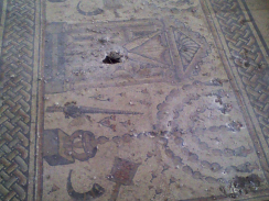 Tiberias - Vandals badly damaged a rare 1,600-year-old mosaic in the northern Israeli city of Tiberias that formed the floor of an ancient synagogue, smashing parts to rubble and scrawling graffiti, antiquity officials said Tuesday. The mosaic, dating 400 years after the birth of Jesus, was one of the best preserved and beautiful of its period, according to archaeologists. It featured illustrated zodiac signs and the traditional symbolism of a fourth-century synagogue: ritual candelabras and palm fronds. The synagogue's ruins, including its ancient mosaic floor, were in a fenced-off area of a national park in Tiberias, next to the Sea of Galilee.
http://www.cbsnews.com/8301-501713_162-57443129/1600-year-old-mosaic-at-israeli-synagogue-damaged/
SUISSE – 
 Carouge - Le 15 mai dernier, nous vous révélions cette découverte archéologique sur un chantier de Carouge sans pouvoir préciser la date de ces vestiges. La construction d'un immeuble de logements a permis tout d'abord de mettre à jour une cinquantaine de blocs de calcaire sculptés pesant près d'une tonne chacun. Ils étaient enfouis à 3 mètres de profondeur, près de l'Arve. Ces blocs pourraient provenir d'un monument funéraire antique édifié à la mémoire du centurion romain Marcus Carantius Macrinus. Ces blocs auraient été utilisés au XIXe siècle pour stabiliser les berges de l'Arve. Ils auraient été déterrés en 1805 non loin de la rivière en compagnie d'autres blocs comprenant cette fois des inscriptions. Ces vieilles pierres sont aujourd'hui exposées dans la mairie de Carouge et au Musée d'art et d'histoire de Genève. Les travaux de construction de l'immeuble de logements ont aussi conduit à la découverte, le 30 avril dernier, de madriers de chêne datant du début du XIIe siècle. Les pieux, qui se trouvaient à 4,5 mètres de profondeur, étaient assemblés verticalement et horizontalement. La dendrochronologie et des analyses au carbone 14 ont permis de dater la structure. Celle-ci a dû être réalisée vers 1115. Son emplacement laisse à penser qu'il s'agissait d'éléments d'un pont qui permettait de traverser l'Arve. La présence d'une léproserie à proximité, mentionnée en 1243, accréditerait cette hypothèse.
http://www.20min.ch/ro/news/geneve/story/17293206
ITALIE – Padoue - This morning, the 5.8 earthquake shakes northern Italy, after the earthquake last week, other damags to the heritage. The earthquake felt throughout northern Italy has also caused damages between Padua and Venice. In Padua, in the basilica of St. Anthony, long cracks cut from side to side, the domes of the church. Archaeology student and photographer InsideIre lives near the Basilica of St. Anthony in Padua, Italy, so she walked over to the church after she felt the earthquake today to see the damage. Normally photography inside the church is not allowed, but the guards allowed her to document the cracks in the ceiling. She photographed three photos of cracks: one in the dome of stars and two long cracks in the main dome. 'Between Padua and Venice, we are not directly affected, but we feel all the shocks, were still evacuate all schools in Padua as a precautionary measure and other damages were also recorded throughout northern Italy, like in Venice. But we always talk about damage secondary, instead to central Italy,' she said.
http://ireport.cnn.com/docs/DOC-796058
ROYAUME UNI – Orkney - A team from the universities of St Andrews, Wales, Dundee, Bangor and Aberdeen (UK), led by Orkney based archaeologist Caroline Wickham-Jones, have just completed mapping what would have been the Orkney (Scotland) coastline from 10,000 years ago. Since that time, at the end of the last Ice Age, sea levels in the area have risen by approximately 30 metres, dramatically changing the landscape. The project is known as 'The Rising Tide Project - The Submerged Landscape of Orkney' and has taken a year to complete. One of the most remarkable findings shows that the entrance into Scapa Flow was severely restricted as the waters between Fara, Flotta and South walls had disappeared, just leaving a very narrow passage between Flotta and Hoxa Head. When thinking of the first settlers to arrive, 10,000 years ago, Caroline Wickham-Jones has some interesting thoughts on what they would have seen "If you consider that you'd be in a low skin boat - I think it would have been quite spectacular, with massive cliffs towering over you on either side". She goes on to say "The map does answer the question why there is so little evidence of the first people that came to Orkney, and that is because what survives is likely to be under water". The study and mapping involved combining the results of sedimentary samples with bathymetric data. It is thought that the same techniques could be applied to a study of 'Doggerland' - the landmass that linked eastern Great Britain to Europe at the time of the last Ice Age.
http://www.stonepages.com/news/
JAMAIQUE –  Port Royal - Archaeologists said Tuesday that they’ll ask the United Nations’ cultural agency to bestow world heritage status on Port Royal, the mostly submerged remains of a historic Jamaican port known as the “wickedest city on Earth” more than three centuries ago. The sunken 17th century city was once a bustling place where buccaneers including Henry Morgan docked in search of rum, women and boat repairs. In recent days, international consultants have conducted painstaking surveys to mark the old city’s land and sea boundaries to apply for the world heritage designation by June 2014, said Dorrick Gray, a technical director with the Jamaican National Heritage Trust, a government agency responsible for preserving and developing the island’s cultural spots. Port Royal was the main city of the British colony of Jamaica in the 17th century until an earthquake and tsunami submerged two-thirds of the settlement in 1692. It boasted a well-to-do population of roughly 7,000 at the time, and was comparable to Boston during the same period. After the quake, the remainder of the town served as a British royal navy base for two centuries, even as it was periodically ravaged by fires and hurricanes. But in recent decades, underwater excavations have turned up artifacts including cannonballs, wine glasses, ornate pipes, pewter plates and ceramic plates dredged from the muck just offshore. The partial skeleton of a child was found in 1998.