Blake de Pastino
Source - http://westerndigs.org/ceremonial-axis-road-discovered-in-heart-of-ancient-city-of-cahokia/
After more than 85 years of study and speculation, recent digs have confirmed the presence of a ceremonial road running through the heart of Cahokia, the largest prehistoric city north of Mexico, archaeologists report.
The broad, elevated road, known as a causeway, extends for at least a kilometer through the center of the ancient city, which is situated just east of modern-day St. Louis.
While the existence of such a road had been the subject of debate and conjecture since the 1920s, the excavations finally confirm its presence, potentially changing our understanding of the Mississippian metropolis, said Dr. Sarah Baires of the University of Illinois.
“This is very exciting research, because I have documented and confirmed the existence of a 1 kilometer-long earthen feature that has never been confirmed before,” Baires said in an interview.
“It is a new monument at Cahokia, and one that oriented the rest of the city’s urban plan.”

A map of Cahokia made in 2011 using Light Detection and Ranging, or LiDAR, reveals traces of a causeway leading north from the midpoint of Rattlesnake Mound (LiDAR imaging courtesy of the Illinois State Archaeological Survey)
The road, dubbed the Rattlesnake Causeway, is an elevated embankment about 18 meters wide that stretches from Cahokia’s Grand Plaza south through the center of the city, where it dead-ends in the middle of the burial feature known as Rattlesnake Mound.
Archaeologists had first detected traces of the feature in 1927, but subsequent investigations raised questions about whether it was human-made or natural. Some experts later thought it might have been the bed of an early railroad.
But in the summer of 2011, a University of Illinois field school, under the direction of Baires and Dr. Timothy Pauketat, resumed study of the feature, and the following year, Baires began digging, excavating sections more than 8 meters wide and 2 meters deep at its northern and southern ends.
The excavations at the southern end revealed distinct layers of fill dirt, deposited with a technique seen in many of Cahokia’s famous monumental earthworks, Baires said.
“This method of construction is seen in the ways Cahokians built other mounds,” she said.
“They used many different methods for moving earth, but one in particular consisted of taking baskets, filling them up with the prepared soils and then dumping those fills out on top of one another to create the feature.”
The digs also turned up a few crucial fragments of datable material: pottery and charcoal.
The pottery sherds bore signs of a tempering technique that was common from the mid-11th century until about 11oo CE, Baires said, and a sample of the charcoal yielded dates from an almost identical range.
This places the construction of the Rattlesnake Causeway at about the same time as the culture’s so-called Big Bang — a period beginning around 1050 when Cahokia underwent remarkable and rapid development, transforming from a mere village into a burgeoning metropolis of up to 10,000 people in a matter of decades.
“Based on the context of the earthen feature and the presence of shell-tempered, early forms of pottery, I argue that [the construction date of] this feature is earlier rather than later,” Baires said of the causeway.
“Why would Cahokians have built this 1 kilometer-long earthen feature after they constructed everything else?
“To me, it makes much more sense that this was one of the foundational pieces of the Cahokian landscape.”
Adding to the evidence that the road may have been a literal and symbolic centerpiece of the city, Baires noted that it is aligned 5 degrees east of north, forming a central “axis” around which the community seems to have been built.

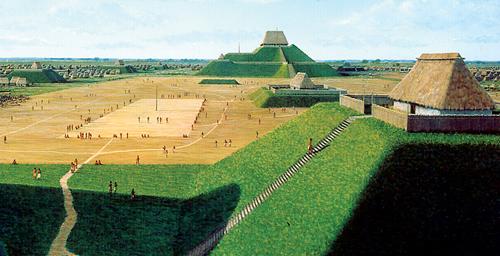
An artist’s rendering depicts Cahokia’s city center at its prime (Painting by L. K. Townsend/Cahokia Mounds State Historic Site)
Since the 1950s, archaeologists have noted that the city’s major mounds, plazas, and households were all oriented along this 5-degree alignment, Baires said. But the discovery of the causeway seems to indicate that the road marked the axis itself.
Previous research has suggested that Cahokia’s buildings align with a celestial event known as the lunar standstill, when the moon rises at its southernmost point in the sky.
The event occurs once every 18.6 years, and, as seen from Cahokia’s Grand Plaza, it is visible over the bluffs south of Rattlesnake Mound, where the causeway ends.
While the significance of this astronomical event, if any, to ancient Cahokians remains unclear, Baires pointed out that the road’s relationship to some of the city’s most important mortuary mounds is likely a key to understanding its purpose.
Rattlesnake Mound, for example, is one of only two ridge-topped mounds in Cahokia’s central district and is its second-largest burial mound, excavations in the 1930s having revealed more than 140 interments there.
And midway down the road’s length, the causeway also runs alongside Mound 72, the site of hundreds of burials, including mass graves of sacrificial victims, and the ornate, shell-covered remains of a man known as the Beaded Burial.
These spatial relationships suggest that the Rattlesnake Causeway served as a sort of conduit between the realms of the living and the dead, Baires said.
“This causeway connects the second largest mortuary mound at the site with the Cahokia’s central precinct, as well as orients the organizational grid of the entire city of Cahokia,” she said.
“It is also importantly tied to mortuary mounds, emphasizing the importance of death and burial at Cahokia.”
Many questions remain about the structure and function of this newfound feature, Baires said, and she intends to continue looking for answers.
“Of course, I will be returning to this feature in the next few field seasons to test more of this feature and acquire more concrete time frame,” she said.
Baires reports her current findings in the Midcontinental Journal of Archaeology.
Baires, S. (2014). Cahokia’s Rattlesnake Causeway Midcontinental Journal of Archaeology, 39 (2), 145-162 DOI: 10.1179/2327427113Y.0000000005