PAP - Science and Scholarship in Poland
Source - http://www.naukawpolsce.pap.pl/en/news/news,398508,new-information-on-early-medieval-strongholds-in-central-poland.html

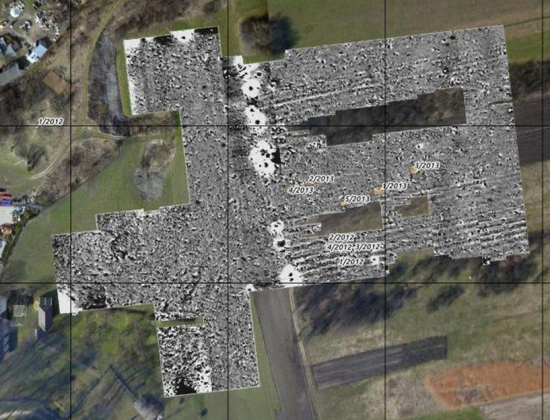
Żarnów. The results of magnetic measurements against the background of an orthophotograph made from aerial photographs by Wiesław Stępień.
Non-invasive archaeological study of six early medieval strongholds yielded surprising results, even though all sites had previously been excavated - reported Jerzy Sikora from the Institute of Archaeology of the University of Łódź.
Archaeologists focused on sites in Chełm, Rękoraj, Rozprza, Stare Skoszewy, Szydłów and Żarnowo. They used a wide range of modern research methods: electrofusion and magnetic prospection, analysis of the concentration of phosphorus in the soil, surface studies combined with GPS registration of material. Archaeologists also used existing LiDAR (aerial laser scanning) documentation, available in the resources of the Geodesic and Cartographic Documentation Center.

"New information concerns primarily not the strongholds themselves, but their surroundings. We have identified parts of impossible to identify with the naked eye in the field or previously unknown fortifications, roads, dikes, and even the extent of surrounding settlements" - said Dr. Sikora.

Stronghold on Mount Chełmo. Digital Terrain Model based on ALS LiDAR measurements made for the ISOK programme.
Archaeologists draw particular attention to the results of the work in Chełm. The analysis allowed to identify previously unknown defences - walls and moats, positively verified later in the field.
"After the initial stage of research, it turned out that we were dealing with the largest, in terms of area, stronghold of the Central Poland, and one of the largest in the country" - believes Dr. Sikora.

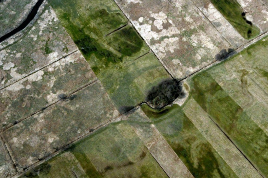
Rozprza. Aerial photograph of the settlement. Photo by: Wiesław Stępień.
The stronghold was surrounded by seven lines of walls and moats, some of which ran full circuit, while others had the form of sections. Recent studies also showed that the stronghold area exceeded 11 hectares.
"The object was many times larger than the most important centres in the region: Łęczyca, Sieradz and Rozprza" - added the archaeologist.
Geophysical survey was performed only in the area of 3 hectares. However, it showed that the spatial structure of the stronghold interior had been even more complex than the preserved terrain form would suggests. Archaeologists registered magnetic anomalies suggesting the existence of additional, internal divisions and roads inside the fortress.
In Chelm, researchers also analysed the content of phosphorus compounds in the soil. The concentration was high, which indicates high intensity of settlement processes. According to the archaeologists, vast area enclosed by embankments was used economically by a group of permanent residents.
"We think this was a bustling object, an important settlement centre, surrounded by numerous open settlements, recorded during the study of the Archaeological Image of Poland" - explained head of the project.
The second site, which caught the attention of researchers, was Rozprza. Until now it was thought that the castle in this place was founded in the ninth century, and inhabited until the fourteenth century. It was supposed to be small, with an internal diameter measuring only 18 m.
Already an analysis of aerial photographs taken in the spring of 2013 allowed to pose new questions concerning the spatial form of the object. Photographs revealed the presence of the second fortified settlement south of the outer wall. These observations have been confirmed by geophysical studies done in the field, as well as detailed surveying. These studies have indicated the existence of mostly levelled, horseshoe-shaped defensive wall that reached the city from the south, forming a classic double system.
"The specificity of non-invasive tests does not allow for a certain determination of chronology of the second segment of the stronghold. On the basis of the analysis of surface material we propose that it functioned in the XI -XIII centuries. A precise determination of the chronology of the object will be possible only after excavations" - said Dr. Sikora.
The study was conducted within the project of the Łódź branch of the Scientific Association of Polish Archaeologists, "Non-invasive study of early medieval strongholds in Central Poland", which received additional funding from the Ministry of Culture and National Heritage under the Fifth Priority "Protection of archaeological sites".
The research results are presented on a website created specifically for this project: http://snap.uni.lodz.pl/grody/